


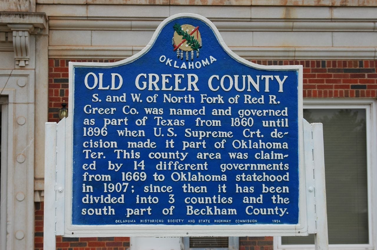
Old Greer County
A little story about when Texas occupied a little bit of Indian Territory and how the United States got it back. Plus, another busy week In The News.

Greer County, Texas?
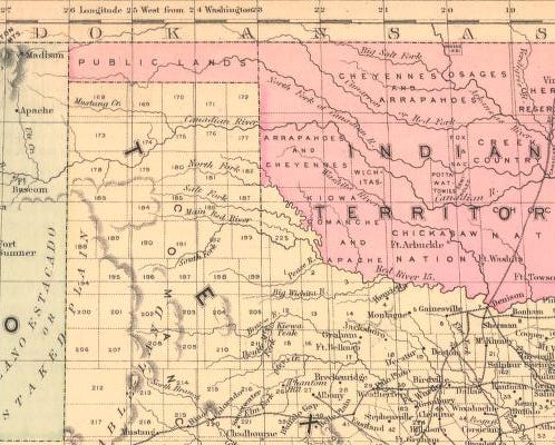
If you ever go back to look at some pre-statehood maps of Oklahoma, you’ll occasionally come across a few that look a little odd. The entire southwestern corner is missing.
Let me tell you a little story about when Texas occupied a little bit of Indian Territory and how the United States got it back.
But first, two important events happened to get us to our story: the Louisiana Purchase from France in 1803 and the Adams–Onís Treaty with Spain in 1819. These two events would define what would be the border between what would later become the States of Oklahoma and Texas. The treaty with Spain is what’s important for our story. It defined the border along the Red River to the 100th meridian.
What they didn’t know at the time was that the Red River forks before it reaches the 100th meridian. A survey in 1852 mistakenly placed the 100th meridian off a degree east, making the meridian intersect the north fork of the Red River. Thus, years of confusion began regarding the Red River and the Texas border. Texas claimed the land south of the North Fork, and the United States claimed the land north of the South Fork.
On February 9, 1860, Texas created Greer County, named in honor of John A. Greer, a former lieutenant governor of Texas, between the north and south forks of the Red River. They started allocating land, setting up post offices, and named Mangum the county seat. This, of course, caused a conflict between the United States and Texas that wouldn’t be resolved for years.
The U.S. Congress passed the Organic Act on May 2, 1890, creating the Territory of Oklahoma. One section of this act required the U. S. attorney general to file a suit to the U. S. Supreme Court to settle the disputed boundary.
On March 16, 1896, the Court ruled (United States v. Texas, 1896) that the southern branch of the Red River was the actual Red River of the 1819 treaty, making Greer County, Texas, part of Oklahoma Territory.
During the Oklahoma Constitutional Convention in 1906, the former Greer County, Texas, was divided into Oklahoma counties: Beckham, Jackson, and Greer. After statehood in 1909, Harmon County was created out of a part of southwestern Greer County, Oklahoma.
Historical markers to Old Greer County can be found in front of the Greer County Courthouse in Mangum and the Harmon County Courthouse in Hollis.
In The News
A look at some of the latest headlines from around Oklahoma and beyond.
Protesters far outnumber Westboro demonstrators in Owasso | Public Radio Tulsa
Xcel Energy says its facilities appeared to have role in igniting Texas wildfire | KAMR
Oklahoma minimum wage petition can move forward, court rules | Oklahoma Voice
Breaking Camp: Lawmakers Take Aim at Homeless Encampments on State Land | Oklahoma Watch
Oklahoma ban on state business with 'woke' banks could topple, or it could expand | KOSU
Oklahoma House passes bill requiring cursive in schools, awaits Senate's decision | KOKH
Say hello to I-335 and I-344: turnpikes around Oklahoma City to get numerical designations | KGOU
Elections: Norman narrowly tells OG&E nay, Wagoner County stomps 8 sales tax votes | Nondoc
'A statue to finish': Holden's last monument completed | Woodward News
Why daily life is so stressful in Oklahoma | The Journal Record
About Oklahoma: Garfield County

Welcome to Garfield County.
Garfield County is in the north-central part of the state. The was formed in 1893 from the Cherokee Outlet as "O" County when the area was opened for settlement. After an election in 1894, the county was renamed after James A. Garfield, 20th President of the United States.
Enid, Oklahoma, is the county seat, the county's largest city, and the ninth-largest city in the state. It's located in the center of the county at the intersection of U.S. Highway 81 and U.S. Highway 412. It's home to Vance Air Force Base, Northern Oklahoma College, the Cherokee Strip Regional Heritage Center, and the Tri State Music Festival.
Other notable communities include Hillsdale, Kremlin, Hunter, and North Enid in the northern, Breckinridge, Fairmont, Garber, Covington, and Douglas in the eastern, Waukomis and Bison in the southern, and Drummond, Lahoma, and Carrier in the western parts of the county.
Established: 1893
County Seat: Enid, Oklahoma 73701
Nation: none
Map: Google Maps
Area: 1,060 mi2 (2,700 km2)
Population: 62,846 (2020 Census)
Time Zone: UTC−6 (Central), DST observed
Area Code: 580
Congressional District: 3
State House District: 38, 40, 58, 59
State Senate District: 19
Weather: NWS Norman
Tourism Region: Red Carpet Country
History: Oklahoma Historical Society
Historic Places: Exploring Oklahoma History
More Information: Wikipedia
Extras
Here are some more things I hope you'll find interesting.
MatPat's FINAL Theory! | The Game Theorists
Hello Retirement | MatPat's Legacy on YouTube
How To Brew Delicious Coffee On The Moka Pot | Morgan Eckroth
Feedback Welcome
If you have any comments or questions, please feel free to leave a comment on Substrack, email me at blogoklahoma@blogoklahoma.net, or connect with me at Mastodon at @blogoklahoma@social.tulsa.ok.us, Threads at @blogoklahoma@threads.net, or Bluesky at @blogoklahoma.bsky.social.
Have a great week.
– K.
Sorry for the day delay in publication. The newsletter typically comes out on Mondays.